


le Pont de l'Alp

jmheydorff
User
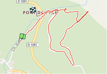

Length
1.6 km

Max alt
1797 m

Uphill gradient
97 m
Km-Effort
2.9 km

Min alt
1680 m

Downhill gradient
71 m
Boucle
Yes
Creation date :
2025-08-03 09:36:28.17
Updated on :
2025-08-03 11:28:45.9
1h08
Difficulty : Easy

FREE GPS app for hiking
 SityTrail
IGN / Geographical institutes
SityTrail Plus
The world is yours!
About
Trail Walking of 1.6 km to be discovered at Provence-Alpes-Côte d'Azur, Hautes-Alpes, Le Monêtier-les-Bains. This trail is proposed by jmheydorff.
Positioning
Country:
France
Region :
Provence-Alpes-Côte d'Azur
Department/Province :
Hautes-Alpes
Municipality :
Le Monêtier-les-Bains
Location:
Unknown
Start:(Dec)
Start:(UTM)
300206 ; 4987913 (32T) N.
Comments